https://sputniknews.in/20240109/isros-ambitious-plan-50-satellites-in-5-years-to-revolutionize-geo-intelligence-6141470.html
ISRO's Ambitious Plan: 50 Satellites in 5 Years to Revolutionize Geo-Intelligence
ISRO's Ambitious Plan: 50 Satellites in 5 Years to Revolutionize Geo-Intelligence
Sputnik India
ISRO aims to launch at least multiple satellites in the next 5 years, enhancing India's strategic surveillance and defense capabilities with advanced remote sensing and intelligence gathering technologies.
2024-01-09T19:47+0530
2024-01-09T19:47+0530
2024-01-09T19:47+0530
sputnik opinion
science & tech
india
mumbai
indian space research organisation (isro)
aditya-l1 mission
chandrayaan
moon
moon mission
moon landing
https://cdn1.img.sputniknews.in/img/07e7/09/0f/4255246_0:0:3077:1731_1920x0_80_0_0_a4fe5495ad91f1758ad5057c5ada969e.jpg
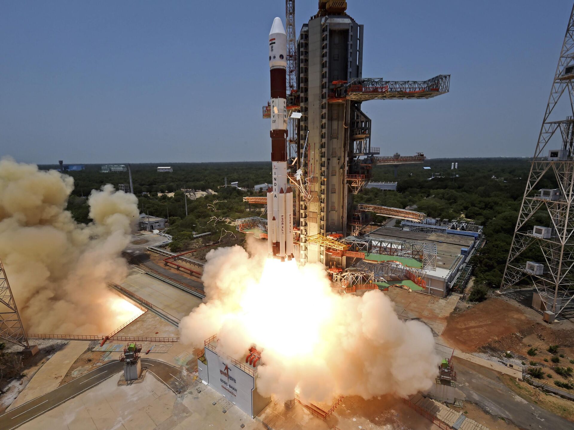
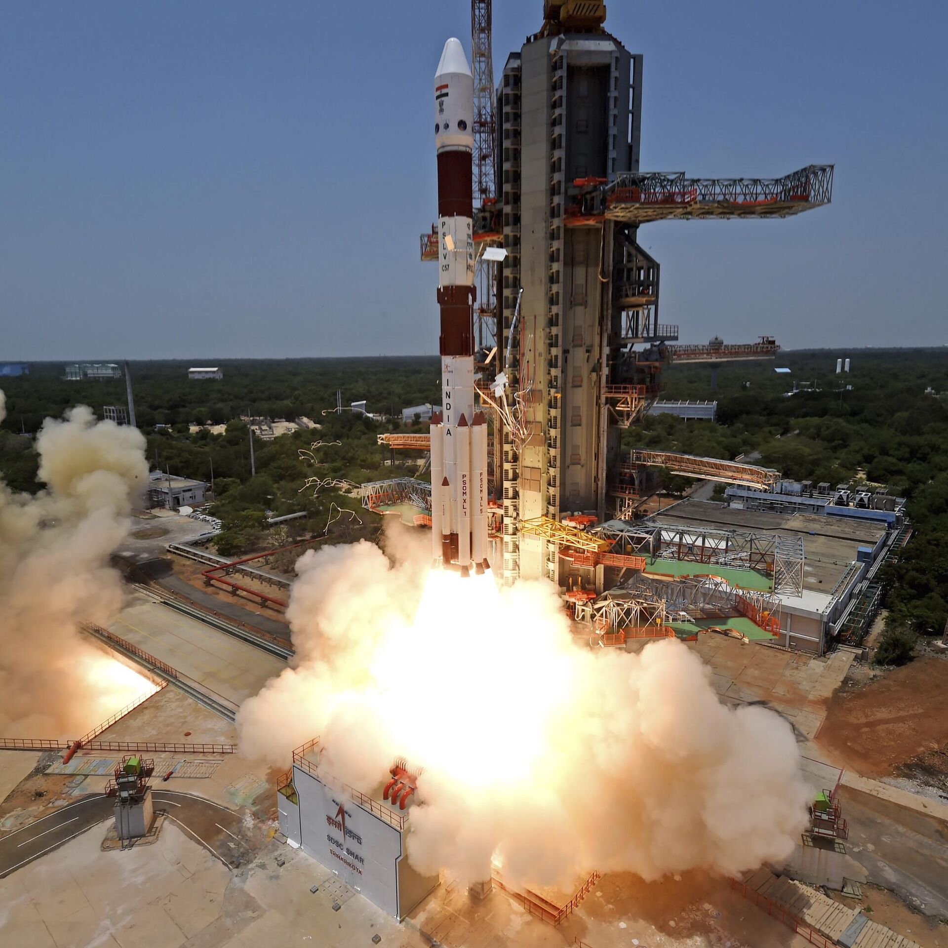
Indian Space Research Organisation (ISRO) chairman S. Somanath said in Mumbai on December 28, 2023 that India aims to launch 50 satellites over the next five years for geo-intelligence gathering.ISRO plans to create multiple satellite constellations operating in orbits suited to the strategic purpose of the constellation.The constellations would perform strategic tasks such as tracking adversary movements over land and sea, real time imaging of emerging threats, high resolution surveillance of adversary military assets, all weather radar imaging, missile launch warning, etc.According to the ISRO Chairman, the number of satellites that India has currently deployed for remote sensing is grossly 40-50.Speaking at `Techfest', an annual science and technology event organised by the Indian Institute of Technology Bombay, he said that the number should be "ten times what we have today".The ISRO chief pointed out that satellites are capable of observing a country's borders and neighbouring regions."We have already configured 50 satellites to be realised in the next five years and this is going to be launched for India for supporting this particular geo-intelligence capability over the next five years plus (period)" the ISRO chief added.Past Remote Sensing SatellitesISRO has progressively enhanced its satellite based intelligence gathering capabilities by launching increasingly capable optical, radar and multi/hyperspectral imaging satellites in low earth sun synchronous polar orbit (SSO).Radar satellites feature a Synthetic Aperture Radar (SAR) that enables them to image the surface of the earth through clouds and in darkness.Unlike optical satellites, multi and hyper spectral imaging satellites have a limited ability to see through clouds.ISRO launched its first HysIS (Hyperspectral Imaging Satellite) launched in November 2018.Cartosat SatellitesCartosats are dual use satellites. Cartosat-2 series (Cartosat-2B, 2C, 2D & 2E) are capable of imaging a swath (geographical strip) of 9.6 km with a resolution of better than 1-m. The satellites are steerable up to ± 26º along as well as across track to obtain stereoscopic imagery and achieve a four to five day revisit capability.ISRO is developing a follow-up Cartosat-3 advanced remote sensing satellite series with a resolution of 0.25 m for cartographic applications and high-resolution mapping.Hysis SatellitesHysis is the first of a new set of future earth observation satellites called hyperspectral (Hyspex) imaging satellites with an orbital height of about 600 km.Hyperspectral imaging is a form of multi-spectral imaging that uses much narrower spectral bands providing more detailed information about the specific wavelengths of light reflected or emitted by the Earth's surface.Hyperspectral sensors capture a large number of narrow and contiguous spectral bands, allowing for more detailed analysis of the electromagnetic spectrum.While multispectral imaging is suitable for some broad-scale assessments, hyperspectral imaging enables distinct identification of objects from space.Hyperspectral imaging may provide better insights through certain cloud types or thin cloud cover compared to traditional multispectral imaging, but it does not guarantee complete penetration through thick clouds.Radar imaging satellites comprise the RISAT series.GISAT SatellitesIn the near future, ISRO plans to launch GEO Imaging Satellites (GISATs) in Geosynchronous orbits (GSO).ISRO's GISAT will carry a geo-imager with multi-spectral (visible, near infra-red and thermal), multi-resolution (50m to 1.5 km) imaging instruments that will enhance the country’s land mapping capabilities. Gisat has both military and civilian use.GISAT will facilitate near real-time imaging of large areas of the country under cloud-free conditions. GISAT images, however, would be of lower resolution than the images from satellites in polar orbit.EOSISRO's EOS (Earth Observation Satellite) combines radar and optical imaging. ISRO launched EOS-1 on November 7, 2020. The satellite was initially intended to be named RISAT-BR2 because Radar Imaging payloads were traditionally carried by RISAT. Because of the additional optical payload, ISRO chose to spawn a new Earth Observation Satellite series.Surveillance SatellitesBesides optical and radar imaging remote sensing satellites, space based intelligence additionally requires other specialised satellites such as ELINT (Electronic Intelligence), Missile Launch Warning and Tracking satellites.EMISATEMISAT is a SIGINT satellite jointly developed by ISRO and DRDO, which was launched into orbit in April 2019.EMISAT was placed in a circular sun-synchronous polar orbit, at an altitude of 749 kilometres and an inclination of 98.4 degrees.In addition to an ELINT payload the satellite likely also features a COMINT (Communication Intelligence) capability.Possible uses of the EMISAT satellites include:Future SatellitesHEO SatellitesBesides more persistent monitoring, HEO satellites have a shorter target area revisit time.Targeting SatellitesCurrent ISRO optical and remote sensing satellites capture imagery which is downloaded and studied by photo analysts on the ground. During the course of hostilities, photo analysts analyse the imagery, identify targets and relay their coordinates to military command centres for onward use by field units.Missile Launch Warning SatellitesMissile launch warning satellites are equipped with powerful Infrared telescopes with cooled sensors to detect the plume of a missile, starting from launch to stage burnout, instantly processing the data to provide coordinates and predict the trajectory of the missiles.The requirement for such a satellite constellation is acute in the Indian context because our adversaries are across our borders. Relying on radar detection will leave no time to react.Layered Satellite ConstellationSpeaking at the TechFest, the ISRO Chief alluded to multi-layered Earth observation, wherein a satellite in GSO, having observed something of interest, could task a satellite in polar orbit to perform higher resolution observation.Communication Satellites for Satellite CommunicationIndian Earth Observation Satellites operating beyond radio horizon may need to communicate with other Indian satellites in orbit in order to relay their data to a satellite control centre in India. ISRO would need to add communication relay features to its future satellites, or create a dedicated communication satellite constellation to facilitate satellite network communication.Such satellites would also facilitate communication between layered communication discussed above.
https://sputniknews.in/20231006/india-soon-to-have-its-own-space-station-isro-chief-4633312.html
india
mumbai
moon
international space station (iss)
Sputnik India
feedback.hindi@sputniknews.com
+74956456601
MIA „Rossiya Segodnya“
2024
News
en_IN
Sputnik India
feedback.hindi@sputniknews.com
+74956456601
MIA „Rossiya Segodnya“
Sputnik India
feedback.hindi@sputniknews.com
+74956456601
MIA „Rossiya Segodnya“
isro, s. somanath, mumbai, 50 satellites, geo-intelligence, satellite constellations, strategic tasks, adversary tracking, real-time imaging, high-resolution surveillance, all-weather radar imaging, missile launch warning, remote sensing, techfest, indian institute of technology bombay, border observation, national security, polar orbit, synthetic aperture radar (sar), optical satellites, multispectral imaging, hyperspectral imaging, cartosat satellites, cartosat-2 series, cartosat-3, hysis satellite, radar imaging, risat series, gisat satellites, geosynchronous orbit, eos, earth observation satellite, surveillance satellites, elint, missile launch warning, tracking satellites, emisat, sigint, sun-synchronous orbit, communication intelligence (comint), heo satellites, targeting satellites, missile launch warning satellites, satellite constellation, communication satellites, satellite communication, geostationary equatorial orbit (geo), lower earth orbit (leo).
isro, s. somanath, mumbai, 50 satellites, geo-intelligence, satellite constellations, strategic tasks, adversary tracking, real-time imaging, high-resolution surveillance, all-weather radar imaging, missile launch warning, remote sensing, techfest, indian institute of technology bombay, border observation, national security, polar orbit, synthetic aperture radar (sar), optical satellites, multispectral imaging, hyperspectral imaging, cartosat satellites, cartosat-2 series, cartosat-3, hysis satellite, radar imaging, risat series, gisat satellites, geosynchronous orbit, eos, earth observation satellite, surveillance satellites, elint, missile launch warning, tracking satellites, emisat, sigint, sun-synchronous orbit, communication intelligence (comint), heo satellites, targeting satellites, missile launch warning satellites, satellite constellation, communication satellites, satellite communication, geostationary equatorial orbit (geo), lower earth orbit (leo).
ISRO's Ambitious Plan: 50 Satellites in 5 Years to Revolutionize Geo-Intelligence
ISRO aims to launch at least multiple satellites in the next 5 years, enhancing India's strategic surveillance and defense capabilities with advanced remote sensing and intelligence gathering technologies.
Indian Space Research Organisation (ISRO) chairman S. Somanath said in Mumbai on December 28, 2023 that India aims to launch 50 satellites over the next five years for geo-intelligence gathering.
ISRO plans to create multiple
satellite constellations operating in orbits suited to the strategic purpose of the constellation.
The constellations would perform strategic tasks such as tracking adversary movements over land and sea, real time imaging of emerging threats, high resolution surveillance of adversary military assets, all weather radar imaging, missile launch warning, etc.
According to the ISRO Chairman, the number of satellites that India has currently deployed for remote sensing is grossly 40-50.
Speaking at `Techfest', an annual science and technology event organised by the Indian Institute of Technology Bombay, he said that the number should be "ten times what we have today".
The ISRO chief pointed out that satellites are capable of
observing a country's borders and neighbouring regions.
"All of it can be seen from satellites. This capability gives us enormous potential. We have been launching satellites to handle this, but there is a different way of thinking now and we need to look at it in a much more critical manner because the power of (any) nation is the ability to understand what is happening around it."
"We have already configured 50 satellites to be realised in the next five years and this is going to be launched for India for supporting this particular geo-intelligence capability over the next five years plus (period)" the ISRO chief added.
Past Remote Sensing Satellites
ISRO has progressively enhanced its satellite based intelligence gathering capabilities by launching increasingly capable optical, radar and multi/hyperspectral imaging satellites in low earth sun synchronous polar orbit (SSO).
Radar satellites feature a Synthetic Aperture Radar (SAR) that enables them to image the surface of the earth through clouds and in darkness.
Unlike optical satellites, multi and hyper spectral imaging satellites have a limited ability to see through clouds.
Optical imaging satellites included the IRS series launched from 1988 onwards, TES satellite launched in 2001, Cartosat satellites launched from 2005 onwards and Resourcesat satellites launched from 2003.
ISRO launched its first HysIS (Hyperspectral Imaging Satellite) launched in November 2018.
Cartosats are dual use satellites. Cartosat-2 series (Cartosat-2B, 2C, 2D & 2E) are capable of imaging a swath (geographical strip) of 9.6 km with a resolution of better than 1-m. The satellites are steerable up to ± 26º along as well as across track to obtain stereoscopic imagery and achieve a four to five day revisit capability.
ISRO is developing a follow-up Cartosat-3 advanced remote sensing satellite series with a resolution of 0.25 m for cartographic applications and high-resolution mapping.
Hysis is the first of a new set of future earth observation satellites called hyperspectral (Hyspex) imaging satellites with an orbital height of about 600 km.
Hyperspectral imaging is a form of multi-spectral imaging that uses much narrower spectral bands providing more detailed information about the specific wavelengths of light reflected or emitted by the Earth's surface.
Hyperspectral sensors capture a large number of narrow and contiguous spectral bands, allowing for more detailed analysis of the electromagnetic spectrum.
While multispectral imaging is suitable for some broad-scale assessments, hyperspectral imaging enables distinct identification of objects from space.
Hyperspectral imaging may provide better insights through certain cloud types or thin cloud cover compared to traditional multispectral imaging, but it does not guarantee complete penetration through thick clouds.
Radar imaging satellites comprise the RISAT series.
In the near future, ISRO plans to launch GEO Imaging Satellites (GISATs) in Geosynchronous orbits (GSO).
ISRO's GISAT will carry a geo-imager with multi-spectral (visible, near infra-red and thermal), multi-resolution (50m to 1.5 km) imaging instruments that will enhance the country’s land mapping capabilities. Gisat has both military and civilian use.
GISAT will facilitate near real-time imaging of large areas of the country under cloud-free conditions. GISAT images, however, would be of lower resolution than the images from satellites in polar orbit.
ISRO's EOS (Earth Observation Satellite) combines radar and optical imaging. ISRO launched EOS-1 on November 7, 2020. The satellite was initially intended to be named RISAT-BR2 because Radar Imaging payloads were traditionally carried by RISAT. Because of the additional optical payload, ISRO chose to spawn a new Earth Observation Satellite series.
Besides optical and radar imaging remote sensing satellites, space based intelligence additionally requires other specialised satellites such as ELINT (Electronic Intelligence), Missile Launch Warning and Tracking satellites.
EMISAT is a SIGINT satellite jointly developed by ISRO and DRDO, which was launched into orbit in April 2019.
EMISAT was placed in a circular sun-synchronous polar orbit, at an altitude of 749 kilometres and an inclination of 98.4 degrees.
In addition to an ELINT payload the satellite likely also features a COMINT (Communication Intelligence) capability.
Possible uses of the EMISAT satellites include:
Location of adversary surface based radar emitters for targeting by anti radiation missiles;
Analysis of radar signals to determine frequency of carriers and subcarriers, modulation, bandwidth, power level, beam footprint parameters, and emitter location and motion. The information would be used to update signal libraries on combat aircraft in order to immediately identify the nature of the radar illuminating the aircraft. The information would also be useful for developing techniques to jam the radar;
Intercepting communication signals, demodulating them, extracting the original data (audio, video, text) for decryption;
Interception and demodulation of non communication signals such as data links for the purpose of extracting and decrypting the data.
The ISRO has so far focused on satellites in Low Earth Orbit (LEO) and Geostationary Orbit (GEO). Most of ISRO's Earth observation satellites are deployed in either LEO or GEO. In the future, ISRO would need to start placing its satellites in Highly Elliptical Orbits (HEOs) for more persistent monitoring of the target area.
Besides more persistent monitoring, HEO satellites have a shorter target area revisit time.
Current ISRO optical and remote sensing satellites capture imagery which is downloaded and studied by photo analysts on the ground. During the course of hostilities, photo analysts analyse the imagery, identify targets and relay their coordinates to military command centres for onward use by field units.
In the future, ISRO will need to develop satellites that can provide target coordinates directly to an aircraft, ship, or a missile system to enable real time strikes on the target. Such satellites would need onboard hardware and software to convert optical or radar sensor data into targeting coordinates for immediate relay to operationally deployed weapon systems.
Missile Launch Warning Satellites
Missile launch warning satellites are equipped with powerful Infrared telescopes with cooled sensors to detect the plume of a missile, starting from launch to stage burnout, instantly processing the data to provide coordinates and predict the trajectory of the missiles.
A missile launch warning satellite constellation is a critical requirement for an effective anti ballistic missile system.
The requirement for such a satellite constellation is acute in the Indian context because our adversaries are across our borders. Relying on radar detection will leave no time to react.
Layered Satellite Constellation
Speaking at the TechFest, the ISRO Chief alluded to multi-layered Earth observation, wherein a satellite in GSO, having observed something of interest, could task a satellite in polar orbit to perform higher resolution observation.
Communication Satellites for Satellite Communication
Indian Earth Observation Satellites operating beyond radio horizon may need to communicate with other Indian satellites in orbit in order to relay their data to a satellite control centre in India. ISRO would need to add communication relay features to its future satellites, or create a dedicated communication satellite constellation to facilitate satellite network communication.
Such satellites would also facilitate communication between layered communication discussed above.
"We have found out a way by which a layer of satellites can be launched starting from GEO (geostationary equatorial orbit) to LEO (lower earth orbit) and also (in) very low earth orbit where we need very critical assessment of some situation," said the ISRO Chief.
 shows the Aditya-L1 spacecraft lifts off on board a satellite launch vehicle from the space center in Sriharikota, India, Saturday, Sept. 2, 2023. India launched its first space mission to study the sun on Saturday, less than two weeks after a successful uncrewed landing near the south polar region of the moon.")

 In this Sept. 18, 2008 file photo, The Chandrayaan 1 spacecraft, India's first unmanned mission to the Moon, is seen as it is unveiled at the Indian Space Research Organization (ISRO) Satellite Center in Bangalore, India")


