https://sputniknews.in/20230613/cyclone-biparjoy-has-extreme-damage-potential-indian-weather-department-2458837.html
Cyclone Biparjoy Has Extreme Damage Potential: Indian Weather Department
Cyclone Biparjoy Has Extreme Damage Potential: Indian Weather Department
Sputnik India
Extremely severe cyclone Biparjoy slightly weakened and is now in the category of a very severe cyclonic storm with a maximum sustained wind speed of 125-135 kmph gusting to 180 kmph, Dr Mrutyunjay Mohapatra, Director General of IMD.
2023-06-13T16:59+0530
2023-06-13T16:59+0530
2023-06-13T16:59+0530
india
gujarat
pakistan
cyclone mocha
thunderstorm
monsoon rains
narendra modi
amit shah
arabian sea
maharashtra
https://cdn1.img.sputniknews.in/img/07e7/06/0d/2463682_0:0:3072:1728_1920x0_80_0_0_2e78489be0426b26ad8bc4c05c1676f6.jpg
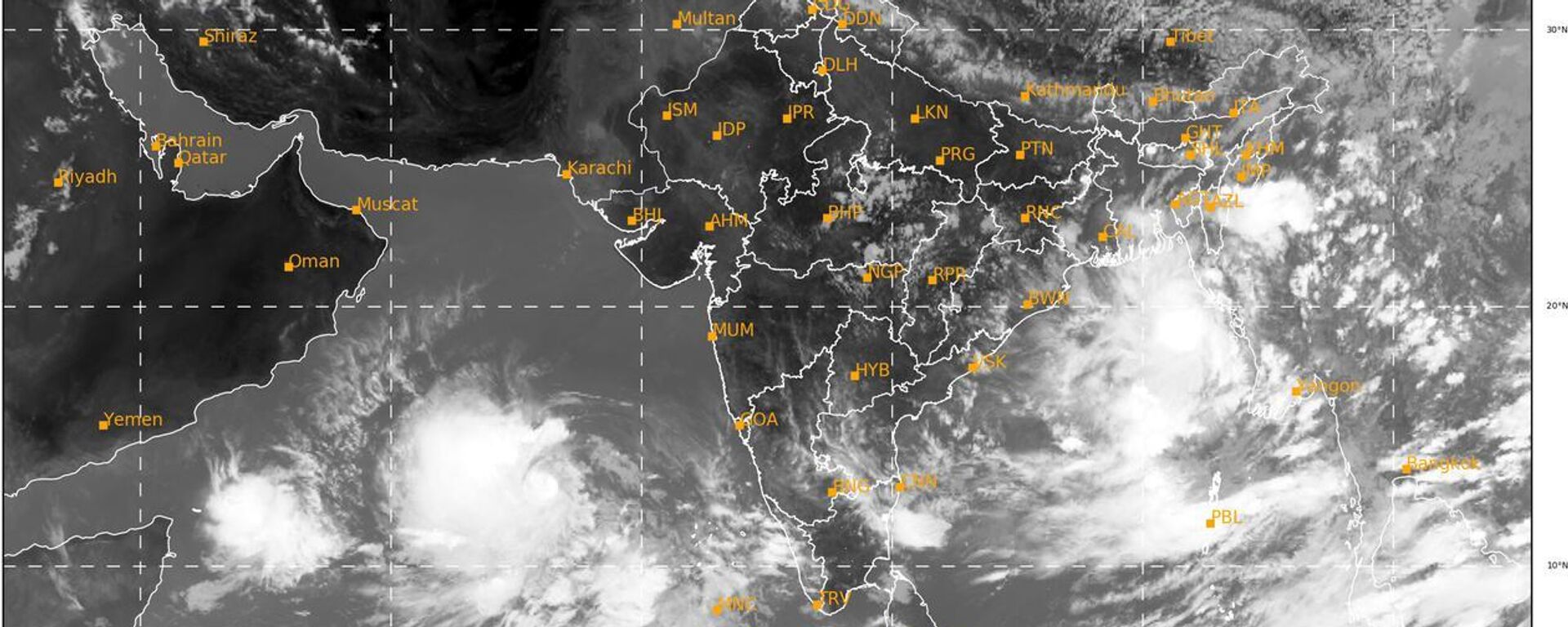
The extremely severe cyclone Biparjoy slightly weakened on Tuesday morning and is currently in the category of a "very severe" cyclonic storm with a maximum sustained wind speed of 125-135 kmph, gusting up to 180 kmph, Dr Mrutyunjay Mohapatra, director general of IMD, has said. Biparjoy is expected to make landfall around Thursday evening between Mandvi in India's Gujarat state and Karachi in Pakistan, with a maximum sustained wind speed of 125-135 kmph.Meanwhile, federal Home Minister Amit Shah chaired a review preparedness meeting on cyclonic storm Biparjoy with the disaster management, ministers of states, and union territories. Cyclone Biparjoy will mostly impact the Jamnagar, Morbi, Devbhoomi Dwarka and Kutch districts of India's western state of Gujarat.The India Meteorological Department (IMD) said on Tuesday that the wind speed is around 60 kmph which will increase to about 85 kmph on Wednesday. On Thursday, 15 June, when it makes landfall, the wind speed will be around 125-135 kmph, gusting to 150 km (93 miles) per hour. Districts may see some damage, including falling of trees, old structures, and rainfall in these places may cause floods in low-lying areas, the IMD said.The IMD continued its orange alert for the Saurashtra-Kutch coast, as Biparjoy is likely to bring heavy rain and squally winds having speeds of 45 to 55 kmph, gusting up to 65 kmph. As per the IMD's prediction, Biparjoy is likely to make landfall near the Jakhau port of Kutch, between Mandvi in Kutch and Karachi in Pakistan, at around noon on 15 June.Here are a few updates on the issue:
https://sputniknews.in/20230611/cyclone-biparjoy-indias-coastal-gujarat-state--closes-beaches-residents-on-alert-2427911.html
india
gujarat
pakistan
arabian sea
maharashtra
karachi
Sputnik India
feedback.hindi@sputniknews.com
+74956456601
MIA „Rossiya Segodnya“
2023
Deexa Khanduri
https://cdn1.img.sputniknews.in/img/07e6/0c/13/138923_52:0:533:481_100x100_80_0_0_cadf23d341691fc65ff2b22fd1afe584.jpg
Deexa Khanduri
https://cdn1.img.sputniknews.in/img/07e6/0c/13/138923_52:0:533:481_100x100_80_0_0_cadf23d341691fc65ff2b22fd1afe584.jpg
News
en_IN
Sputnik India
feedback.hindi@sputniknews.com
+74956456601
MIA „Rossiya Segodnya“
Sputnik India
feedback.hindi@sputniknews.com
+74956456601
MIA „Rossiya Segodnya“
Deexa Khanduri
https://cdn1.img.sputniknews.in/img/07e6/0c/13/138923_52:0:533:481_100x100_80_0_0_cadf23d341691fc65ff2b22fd1afe584.jpg
cyclone biparjoy, home minister amit shah, severe cyclone biparjoy, dr mrutyunjay mohapatra, mandvi, biparjoy, jamnagar, morbi, devbhoomi dwarka, kutch, indian meteorological department, orange alert for the saurashtra-kutch coast, jakhau port, mandvi, bhupendra patel, severe rainfall, heavy rainfall, very heavy rainfall
cyclone biparjoy, home minister amit shah, severe cyclone biparjoy, dr mrutyunjay mohapatra, mandvi, biparjoy, jamnagar, morbi, devbhoomi dwarka, kutch, indian meteorological department, orange alert for the saurashtra-kutch coast, jakhau port, mandvi, bhupendra patel, severe rainfall, heavy rainfall, very heavy rainfall
Cyclone Biparjoy Has Extreme Damage Potential: Indian Weather Department
Deexa Khanduri
Sputnik correspondent
The Indian government is extra cautious ahead of cyclone Biparjoy as it appears to be the strongest of all cyclones since 1982 (when satellite data started being used).
The extremely severe cyclone Biparjoy slightly weakened on Tuesday morning and is currently in the category of a "very severe" cyclonic storm with a maximum sustained wind speed of 125-135 kmph, gusting up to 180 kmph, Dr Mrutyunjay Mohapatra, director general of IMD, has said.
"Its damaging potential could be extensive", Mohapatra said.
Biparjoy is expected to make landfall around Thursday evening between Mandvi in India's Gujarat state and Karachi in Pakistan, with a maximum sustained wind speed of 125-135 kmph.
Meanwhile, federal Home Minister Amit Shah chaired a review preparedness meeting on cyclonic storm Biparjoy with the disaster management, ministers of states, and union territories.
"The States where nuclear power stations have been given a strict protocol to be followed in the case of any emergency,"
Union Home Minister Amit Shah said after the meeting.
Cyclone Biparjoy will mostly impact the Jamnagar, Morbi, Devbhoomi Dwarka and Kutch districts of India's western state of Gujarat.
The India Meteorological Department (IMD) said on Tuesday that the wind speed is around 60 kmph which will increase to about 85 kmph on Wednesday. On Thursday, 15 June, when it makes landfall, the wind speed will be around 125-135 kmph, gusting to 150 km (93 miles) per hour.
Districts may see some damage, including falling of trees, old structures, and rainfall in these places
may cause floods in low-lying areas, the IMD said.
The IMD continued its orange alert for the Saurashtra-Kutch coast, as Biparjoy is likely to bring heavy rain and squally winds having speeds of 45 to 55 kmph, gusting up to 65 kmph.
As per the IMD's prediction, Biparjoy is likely to make landfall near the Jakhau port of Kutch, between Mandvi in Kutch and Karachi in Pakistan, at around noon on 15 June.
Here are a few updates on the issue:
Prime Minister Narendra Modi on Monday had a telephone conversation with Gujarat state chief Bhupendra Patel regarding the status and preparedness for impending Cyclone Biparjoy.
PM Modi also chaired a high-level meeting with the concerned authorities and asked them to evacuate the people.
The Western Railways has cancelled 67 trains passing through the areas predicted to be affected by weather conditions.
Gujarat state government, till Tuesday noon, evacuated 8,000 people from coastal areas and moved them to temporary shelter homes. Schools in six state coastal districts will remain closed starting from Thursday.
The state government is
evacuating people living in huts up to 10 km inland.
Several districts of Gujarat -- Kutch, Jamnagar, Morbi, Gir Somnath, Porbandar, and Devbhumi Dwarka -- are likely to be impacted by the cyclone with heavy rainfall and very high wind speed during 13-15 June, which may go up to 150 kmph.
The IMD has advised fishermen not to venture into the seas off the coast of Gujarat, Kerala, Karnataka, Maharashtra, and Lakshadweep.


